Note
Click here to download the full example code
Shell2 spatial model#
This is a spatial model parametrizing a projected radiating shell.
The shell spatial model is defined by the following equations:
where \(\theta\) is the sky separation, \(r_{\text{out}}\) is the outer radius and \(r_{\text{in}}\) is the inner radius.
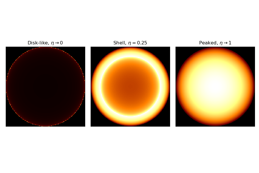
For Shell2SpatialModel, the radius parameter r_0 correspond to \(r_{\text{out}}\). The relative width parameter, eta, is given as eta = \((r_{\text{out}} - r_{\text{in}})/r_{\text{out}}\) so we have \(r_{\text{in}} = (1-\eta) r_{\text{out}}\).
Note that the normalization is a small angle approximation, although that approximation is still very good even for 10 deg radius shells.
Example plot#
Here is an example plot of the shell model for the parametrization using outer radius and relative width. In this case the relative width, eta, acts as a shape parameter.
import matplotlib.pyplot as plt
from gammapy.modeling.models import (
    Models,
    PowerLawSpectralModel,
    Shell2SpatialModel,
    SkyModel,
)

tags = [
    r"Disk-like, $\eta \rightarrow 0$",
    r"Shell, $\eta=0.25$",
    r"Peaked, $\eta\rightarrow 1$",
]
eta_range = [0.001, 0.25, 1]
fig, axes = plt.subplots(1, 3, figsize=(9, 6))
for ax, eta, tag in zip(axes, eta_range, tags):
    model = Shell2SpatialModel(
        lon_0="10 deg",
        lat_0="20 deg",
        r_0="2 deg",
        eta=eta,
        frame="galactic",
    )
    model.plot(ax=ax)
    ax.set_title(tag)
    ax.set_xticks([])
    ax.set_yticks([])
plt.tight_layout()

YAML representation#
Here is an example YAML file using the model:
pwl = PowerLawSpectralModel()
shell2 = Shell2SpatialModel()

model = SkyModel(spectral_model=pwl, spatial_model=shell2, name="pwl-shell2-model")

models = Models([model])

print(models.to_yaml())
Out:
components:
-   name: pwl-shell2-model
    type: SkyModel
    spectral:
        type: PowerLawSpectralModel
        parameters:
        -   name: index
            value: 2.0
            is_norm: false
        -   name: amplitude
            value: 1.0e-12
            unit: cm-2 s-1 TeV-1
            is_norm: true
        -   name: reference
            value: 1.0
            unit: TeV
            frozen: true
            is_norm: false
    spatial:
        type: Shell2SpatialModel
        frame: icrs
        parameters:
        -   name: lon_0
            value: 0.0
            unit: deg
            is_norm: false
        -   name: lat_0
            value: 0.0
            unit: deg
            is_norm: false
        -   name: r_0
            value: 1.0
            unit: deg
            is_norm: false
        -   name: eta
            value: 0.2
            is_norm: false