SkyDisk
-
class
gammapy.image.models.SkyDisk(lon_0, lat_0, r_0, edge='0.01 deg', frame='galactic')[source]¶ Bases:
gammapy.image.models.SkySpatialModelConstant radial disk model.
\[\begin{split}\phi(lon, lat) = \frac{1}{2 \pi (1 - \cos{r_0}) } \cdot \begin{cases} 1 & \text{for } \theta \leq r_0 \\ 0 & \text{for } \theta > r_0 \end{cases}\end{split}\]where \(\theta\) is the sky separation. To improve fit convergence of the model, the sharp edges is smoothed using
erf.Parameters: Examples
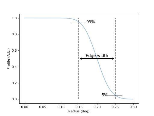
Here is an illustration of the definition of the edge parameter:
import matplotlib.pyplot as plt
from astropy import units as u
from gammapy.image.models import SkyDisk

lons = np.linspace(0, 0.3, 500) * u.deg

r_0 = 0.2 * u.deg
edge = 0.1 * u.deg

disk = SkyDisk(lon_0="0 deg", lat_0="0 deg", r_0=r_0, edge=edge)
profile = disk(lons, 0 * u.deg)
plt.plot(lons, profile / profile.max(), alpha=0.5)
plt.xlabel("Radius (deg)")
plt.ylabel("Profile (A.U.)")

edge_min, edge_max = (r_0 - edge / 2.).value, (r_0 + edge / 2.).value
plt.vlines([edge_min, edge_max], 0, 1, linestyles=["--"])
plt.annotate("", xy=(edge_min, 0.5), xytext=(edge_min + edge.value, 0.5),
             arrowprops=dict(arrowstyle="<->", lw=2))
plt.text(0.2, 0.52, "Edge width", ha="center", size=12)
plt.hlines([0.95], edge_min - 0.02, edge_min + 0.02, linestyles=["-"])
plt.text(edge_min + 0.02, 0.95, "95%", size=12, va="center")
plt.hlines([0.05], edge_max - 0.02, edge_max + 0.02, linestyles=["-"])
plt.text(edge_max - 0.02, 0.05, "5%", size=12, va="center", ha="right")
plt.show()
Attributes Summary
evaluation_radiusEvaluation radius ( Angle).framelat_0lon_0parametersParameters ( Parameters)positionSpatial model center position r_0Methods Summary
__call__(self, lon, lat)Call evaluate method copy(self)A deep copy. evaluate(lon, lat, lon_0, lat_0, r_0, edge)Evaluate the model (static function). to_dict(self[, selection])Attributes Documentation
-
frame
-
lat_0
-
lon_0
-
parameters¶ Parameters (
Parameters)
-
position¶ Spatial model center position
-
r_0
Methods Documentation
-
__call__(self, lon, lat)¶ Call evaluate method
-
copy(self)¶ A deep copy.
-
to_dict(self, selection='all')
-